Scientists 3D Map Energy Jets Blasted Into Atmosphere By Unusual Lightning Storms

Oklahoma is well known for having some wicked thunderstorms that can produce enormous amounts of lightning. These strong storms are often followed by storm chasers hoping to catch the spawning of a tornado. But it was a singular bolt of lightning that caught the attention of Levi Boggs, a research scientist at the Georgia Tech Research Institute. Boggs worked with a multi-organization research team in order to study the gigantic jet that was captured in the video. The team recently published a research paper on its findings in Science Advances, a peer-reviewed, multidisciplinary, open-access scientific journal.
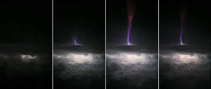
"We were able to map this gigantic jet in three dimensions with really high-quality data," remarked Boggs. "We were able to see very high frequency (VHF) sources above the cloud top, which had not been seen before with this level of detail. Using satellites and radar data, we were able to learn where the very hot leader portion of the discharge was located above the cloud."
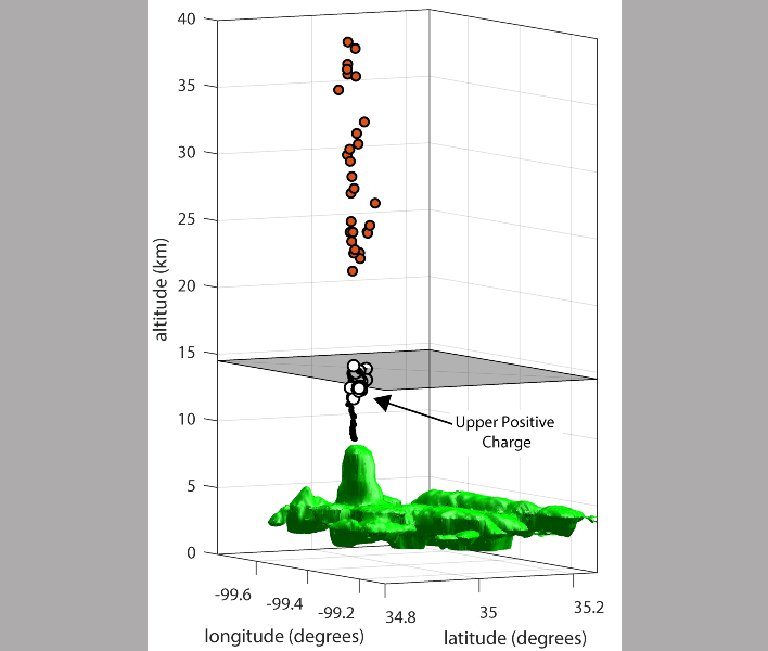
In the image below, radio mapping sources extend up from the convective structure of the storm. The gray plane seen in the image represents the storm's top.
This was a unique event, in that the gigantic jet was detected by several systems, including the Lightning Map Array (LMP) and two geostationary optical lightning systems, according to Doug March, a co-author of the paper. He added that this is more than likely the first time that a gigantic jet had been three-dimensionally mapped above the clouds with the Geostationary Lightning Mapper (GLM).
Researchers theorize that gigantic jets are created by something that may be blocking the flow of charge downward, or toward other clouds. The lightning storm in Oklahoma that produced the studied gigantic jet showed very little lightning activity before it emitted the record gigantic jet.
"For whatever reason, there is usually a suppression of cloud-to-ground discharges," Boggs said. "There is a buildup of negative charge, and then we think that the conditions in the storm top weaken the uppermost charge layer, which is usually positive." He added that with the absence of lightning discharges that are typically seen, the gigantic jet may be the result of the buildup of excess negative charge in the cloud.
Top Image Credit: Antonio Treccarichi from Pexels
