Google Adds 25 Million New Building Footprints to Maps App
Google's been making an especially concerted effort lately to beef up its Google Maps software for desktop and mobile, and the latest addition entails constructing 25 million new building footprints in some of the larger cities and metropolitan areas scattered throughout the United States. These locales include Houston, Los Angeles, Chicago, Miami, and the San Francisco Bay Area.
This is an ongoing effort that will see building footprints added to more locations over time. Google creates them using a special algorithm that examines aerial imagery. Computer vision techniques then use that data to render the building footprints based on shape and height, a process Google claims allows it to provide a more comprehensive and detailed map than ever before.
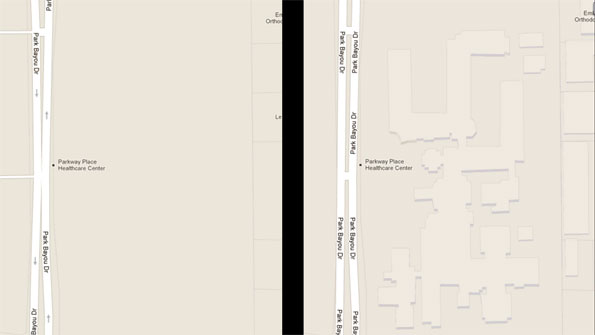
The above image compares an area in Houston, Texas with before (left) and after (right) adding building footprints.
It's a neat addition to Google Maps, though not always 100 percent accurate. To help ensure building footprints are as accurate and up-to-date as possible, Google is encouraging users to take advantage of its community mapping tool, Google Map Maker.
Google's been going bananas updating its Google Maps software ever since Apple kicked it to the curb in iOS 6. Just last week, Google added 250,000 miles of road to Street View, representing the largest update to Google Maps since it was introduced seven years ago.
This is an ongoing effort that will see building footprints added to more locations over time. Google creates them using a special algorithm that examines aerial imagery. Computer vision techniques then use that data to render the building footprints based on shape and height, a process Google claims allows it to provide a more comprehensive and detailed map than ever before.
The above image compares an area in Houston, Texas with before (left) and after (right) adding building footprints.
It's a neat addition to Google Maps, though not always 100 percent accurate. To help ensure building footprints are as accurate and up-to-date as possible, Google is encouraging users to take advantage of its community mapping tool, Google Map Maker.
Google's been going bananas updating its Google Maps software ever since Apple kicked it to the curb in iOS 6. Just last week, Google added 250,000 miles of road to Street View, representing the largest update to Google Maps since it was introduced seven years ago.